Obj. ID: 51242
Jewish Funerary Art Jewish cemetery in Baligród, Poland - Photos of 2020
To the main object: Jewish cemetery in Baligród, Poland

According to ESJF European Jewish Cemeteries Initiative, the cemetery was established at least as early as the mid-17th century and was in use until the Holocaust. It is located about 200 meters north-west of the market square, outside the dense town. Its grounds are laid out in an elongated, irregular polygon. The cadastral map from 1850 shows the final area of 0.95 hectares, which is still the same today. On the western side the cemetery borders a street, behind which there are residential buildings, and in the past, there were fields or gardens. On the southern side, it borders a dirt road, behind which there are fields. Its northern border is natural, in the form of a steep slope. Its western border is currently unclear, as the area of the cemetery blends with an arable field. The entrance to the cemetery is on its eastern side. Next to the entrance, there was a building, likely a funeral home, located in the cemetery.
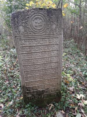
The cemetery was devastated during World War II. The tombstones were used for construction purposes, including hardening the surface of the market square, where they remain, although now they are covered with a new surface layer. Around 300 tombstones in various conditions have survived in the cemetery, mostly in their original places. According to the information board at the site, the earliest gravestone is from 1716. According to sztetl.org it's from 1731, and there are around 250 tombstones. Based on the pictures from the survey team, there are 42 gravestones.
Date of the oldest tombstone: 1734
Date of the newest tombstone: 1908
There are several damaged tombstones, likely from the 17th century. The traditional layout of graves is visible in the cemetery. Tombstones are arranged in regular rows from north-west to south-east. These are partitioned into male and female sections. Tombstones are mostly made of local flysch sandstone which has been subject to natural erosion. Some of the early tombstones are made of limestone and some 20th-century ones are made of concrete and terrazzo. The preserved tombstones are traditional stelas. In some cases, there is a block lined up along the grave, there is also one obelisk. Tombstones from the second half of the 18th century and the 19th century are richly decorated with plant and animal motifs with folk art characteristics. The area of the cemetery is covered with decade old tree and bush growth. The cemetery was entered into the Register of Monuments in 1990.
To reach the cemetery, start from Wojska Polskiego Street, proceed to Jana Duplaka street. There are signs and two entrances - on the right and left, up the hill.