
Obj. ID: 40959 Palaestina ex munumentis by Adrian Reland, Nuremberg (Nürnberg), 1716

6 image(s)


sub-set tree:
This text was prepared by William Gross:
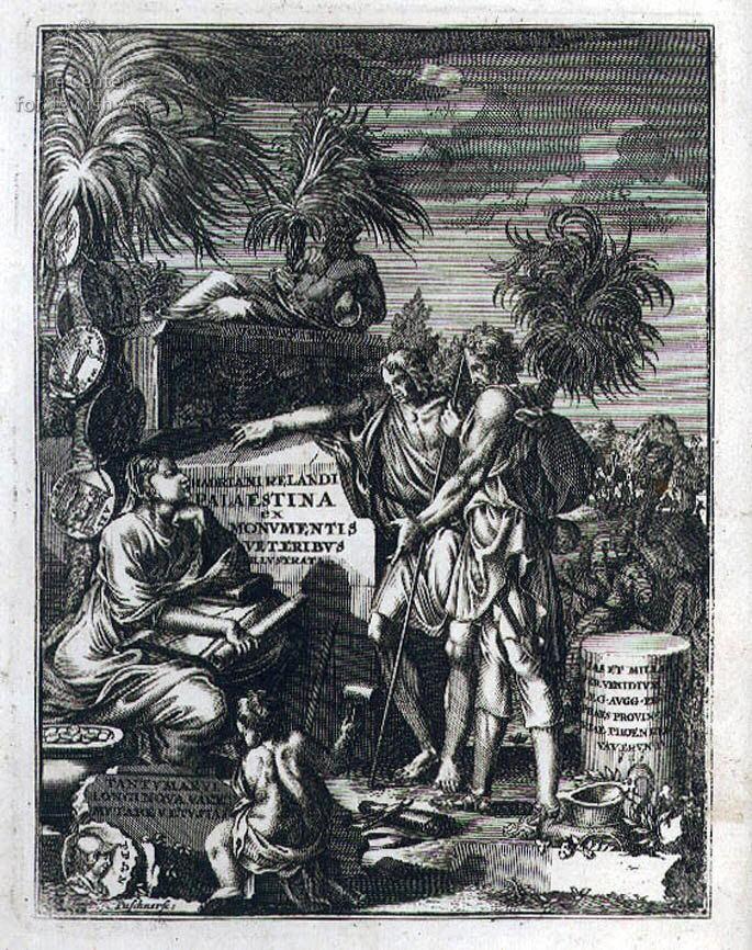
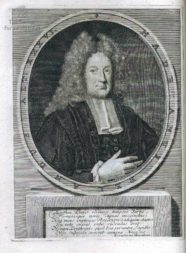
Palaestina ex Monumentis Veteribus Illustrata, by Adriaan Reland. Utrecht (Trajecti Batavorum), 1716. Latin, some Greek, Hebrew and Arabic. Two parts. Second edition. Study of Palestine. Contains 16 engraved plates (seven are folding), including a portrait of the author, maps and charts, a frontispiece and several small in-text engravings. Adriaan Reland (Adriaan Reelant / Adriaan Reland / Hadriani Relandi, 1676-1718), was a Dutch geographer, cartographer, philologist and one of the first orientalists. Professor of oriental languages at the University of Utrecht from 1701 and lecturer on the history of the Jewish people. In 1695, Reland was sent to Palestine, where he conducted a survey of 2,500 settlements, mapped them and conducted surveys and censuses, all recorded in this volume. [5] leaves, 511, [1] pp; [2] leaves, [515]-1068 pp, [47] leaves [16] plates. 20 cm
One of the most famous books of Reland. It is a celebrated work of the Dutch Hebraist, an expert on the ancient history of Palestine. Brunet 22738. Palaestina ex Monumentis veteribus Illustrata, Tomus I-III, Hadriani Relandi. Utrecht, 1716. Latin, with some Greek, Hebrew and Arabic. Two Volumes.Apparently second edition. Comprehensive study of the geography of Eretz Israel, accompanied by fifteen engraving-plates (folded): illustrated title page, maps of Eretz Israel, author's portrait, chronological charts, and more.
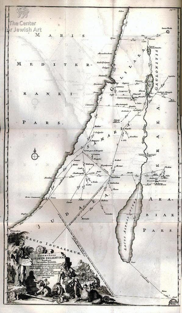
Adriaan Reland ( 1667-1718), the celebrated Dutch Orientalist, was proFezsor of Oriental languages and ecclesiastical antiquities at the University of Utrecht. His description of Palestine is remarkable work for its time, especially considering the fact that his description of the city is not based on his travels but collected from accounts of other authors. In the preface Relandus declares to have mistrusted all the existing cartographical material, and to have reconfigured Palestine’s topography on the bases of the printed sources, which included the Rabbinical and Arabic ones. He draws special attention to his map of distances to the formation of which the whole book II is devoted: being a careful reconstruction of interrelated and Arabic ones. He draws special attention to his map of distances to the formation of which the whole book II is devoted : being a careful reconstruction of interrelated distances as mentioned in the literature it forms a building in which each stone closely connects with the others and can’t be taken out without affecting the other parts. The third book, usually bound separately with the second title-page, is taken up by a comprehensive topographical dictionary of the Bible. In his chapter on Lebanon (pp. 311-22). Relandus quotes Maundrell’s description which was published without a map; he is now able to offer one (p. 320) after the autograph copy of Maundrell himself through the good offices of the brothers Masson. From them he also received the illustration of Punic coin p. 1014, and when discussing the town of Petra, now called Agra, he reproduced French letter by Jacques de Bary (pp. 934-51) which explains a number of coins illustrated by 6 engravings. Blackmer 1406; Tobler p. 312.
This remarkable work is an early geographical survey of biblical Palestine. Reland was eminently qualified to conduct this exhaustive survey: He was a geographer, cartographer and a polylinguist, possessing - in addition to the European languages - full command of Hebrew, Arabic and classical Greek. His journey encompassed 2500 sites mentioned in the Bible, Mishna and Talmud. He began by mapping Eretz Israel, employing plane-table topography, triangulation and a sextant for an extremely accurate map. He then identified each and every site mentioned in the Bible, Mishna and Talmud with the source of its name. If it was a Jewish source, he quoted the appropriate text from Scripture. If the place name was Roman or Greek in origin, he supplied the source for those. He also conducted a census of each such habitation, with the following data: 1. Not one place in Eretz Israel has a name that originates in Arabic. Place names are Hebrew, Greek or Roman (Latin), that were given meaningless Arabic derivations. Akko, Haifa, Yafo, Nablus, Gaza or Jenin have no meaning in Arabic, and city names like Ramallah, Al-Khalil and Al-Quds lack historic or philological Arab roots. In 1696, the year of the survey, Ramallah was called Bt’ala (=Beit-El), Hebron was Chevron, and the Cave of the Machpela was Al-Khalil, Arabic for patriarch Avraham. 2. The country was a wasteland. Its few inhabitants were concentrated in cities like Jerusalem, Acre, Safed, Jaffa, Tiberias and Gaza. Most of the city folk were Jewish or Christian, and only a few Muslims, usually Bedouins. Nablus (Shechem)was an exception, home to some 120 Muslims and 70 Shomronim (Samaritans). Natzeret (Nazareth), capital of the Galilee, was inhabited by 700 Christians. Some 5000 people lived in Jerusalem, most of them Jews. Interestingly, Muslims are mentioned only as nomadic Bedouins, who served as seasonal agriculture and construction workers. The population of Gaza was equally divided between Jews and Christians. The Jews raised grapes, olives and wheat crops., while the Christians were occupied in commerce and transportation of goods. Safed and Tiberias also had Jewish communities, but the only occupation mentioned is fishing in the Sea of Galilee. A city like Um-al-Fahm, for example, is mentioned as a small village consisting of 10 Christian families, with a small Maronite church." Thus, the main testimony of this survey is that the area referred to as "Palestine" was virtually empty, except for settlements of Jews and few Christians.This work is profusely illustrated with 9 original steel engraved maps (including 3 folding), a folding genealogical table of the Herods, a folding table comparing ancient measures of distance, a portrait of the author plus 2 other engraved plates. Includes steel engraved in-text illustrations of ancient coins as well as a number of tables displaying Semitic linguistic scripts.
. [5] leaves, 511 pp [15] plates; [3], 516-1068, [94] pp